Thermal imaging is gaining popularity as technology increases. The benefits and advantages of it have a part in multiple industries. Of course one of the most interesting areas of thermal imaging is the option of using a drone to fly the system and see things from the sky. This article goes over the basics of how thermal imaging systems work, where they apply, and how they work with drone systems.
What is Thermal Imaging?
Unless something has a temperature of absolute zero, which only exists in the minds of physicists, it gives off some amount of infrared radiation (IR). The higher the temperature, the more radiation is emitted. Under normal circumstances, we cannot see infrared because the wavelengths are too long and our eyes do not detect them. When we want to tell if something is hot or cold we have to rely on touch or on using context clues.
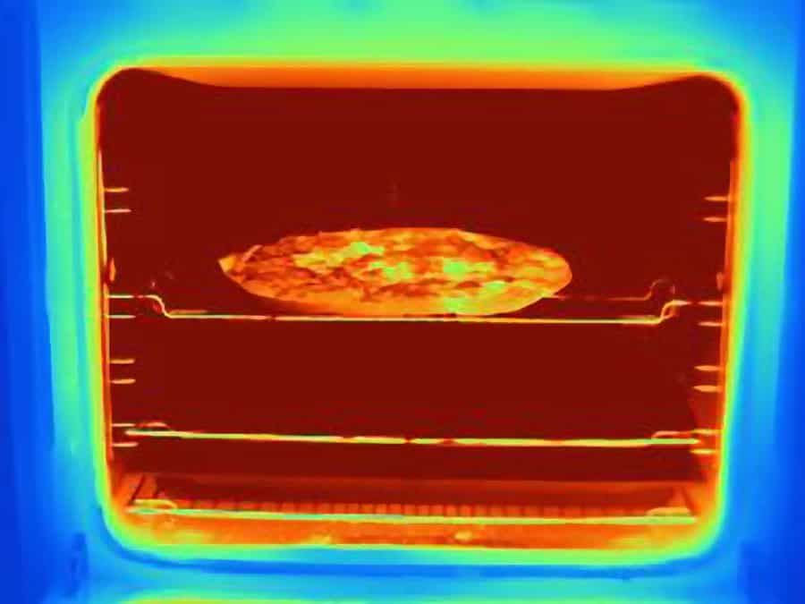
Thermography, or Thermal Imaging, is the process of using sensors to translate that radiation into something we can see. With IR cameras we can see whether or not something is hot and compare its relative temperature to the area around it. Like, check out this tasty looking pizza cooking in the oven. You can see those bright yellow almost white-hot sections in the middle of the pizza. Those are the damn parts that burn the hell outta your mouth when you can’t wait for your pizza to cool.
Thermograms are created by using a special lens that focuses the light and a phased array of infrared detector elements. This process happens in an instant, about 1/30 of a second, for the detector array to receive the temperature data.
In the early days of thermal imaging, you had to rely on expensive cameras that were usually produced for military or paramilitary applications and would give you grainy, hard to see images. Today’s cameras can give you amazing definitions, with colors representing intensities and adjustable ranges as seen above. Often times you can set what range of colors you’d like to see representing the temperatures. Sometimes a black and white scheme is better utilized over all the colors.
Technology, as expected, has improved vastly over the years. The cost of thermal cameras has come down quite a bit. In fact for just over $200 you can get a decent little thermal camera that connects to your smartphone. Check it out on Amazon here. At the top of the thermal camera market is a company called FLIR.
FLIR Systems, Inc. designs, develops, manufactures, markets, and distributes technologies that enhance perception and awareness. We bring innovative sensing solutions into daily life through our thermal imaging, visible-light imaging, video analytics, measurement and diagnostic, and advanced threat detection systems.
About page FLIR.com
Applications
Due to companies, like FLIR, that are pushing the technology and the decreasing cost, thermal imaging with drones has become a staple of many trades. This includes roofers looking for cold leaks on a warm ceiling, firemen looking for hot spots through the smoke, and search and rescue teams looking for human body heat against the cold ground.
Many of these industries were able to quickly adapt drones to hold thermal cameras or IR Sensors. When covering hard to reach or large areas drones are a perfect complement to the technology. A single roofer can fly a small drone with a thermal camera and inspect areas without a ladder or needing to get onto the rood safely. A fire crew can fly over large areas without the expense or danger of a helicopter. I’ll get more into the industries shortly…
Hobbyists and professional operators with infrared capability can be found volunteering with search and rescue, or just out there innovating new ways to use the technology and drones for fun. With prices falling for sensors and manufacturers building dedicated drones for IR operations, this is a tool that many pilots are adding into their kits.
For example, in October 2019 a search and rescue effort was pulled together quickly to help look for missing 6-year-old boy, named Ethan. More than 600 people and some officials rallied together to help look for him in the cold Minnesota night. It was 2 AM and Ethan had been missing for 10 hours when Steve Fines, owner of Fines Imaging a drone imaging company, came to the rescue.
He utilized his 640×480 30Hz Advanced Radiometric FLIR camera and covered a large area before quickly honing in on the heat signature of the boy and his dog curled up in the field more than a mile from his home. What an amazing example of how useful and life-saving this technology can be! Check out the video below for the story!
The 3 big Industries for Thermal Imaging With Drones
As briefly mentioned before there are numerous industries that can take advantage of thermal images from above. Anything involving flying at night, for instance, can use thermal cameras for navigation. Hunters and biologists will often use it for tracking animals, military and police can use it for tracking populations or checking areas for potential threats. However, Forestry, Search & Rescue and Inspection are the 3 areas that are the most popular places to find drones utilizing thermal imaging.
Fire Watch
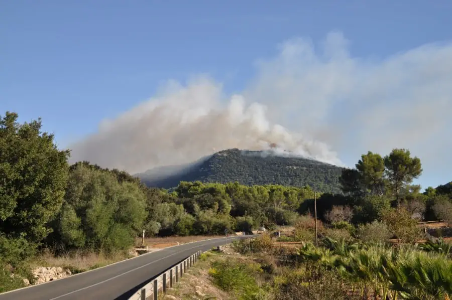
In 2018 wildfires burned more than 8.8 million acres of land in the US. We are always looking for ways to reduce the risk and contain fires before they get out of control, and in fact, the Department of Interior was one of the first agencies in the government to push for the wide-scale adoption of drones as tools.
While some of the drones they use are a little outlandish/creative, like using Drone systems that drop flaming ping pong balls to create backfires or prescribed burns. Thermal imaging platforms that find hot spots and potential fires has become a large part of protecting forests and houses.
Drones can fly high above the trees or up and over mountains searching for any possible issues. If they find an issue they can remain in flight and be the eyes of fire crews, who might not be able to see the problems through the trees or through the smoke.
On a somewhat smaller scale infrared capable drones will instantly highlight people who are up to no good, be it teenagers setting off fireworks or poachers illegally staking out prey, and allow the police to step in even before a fire starts.
There are many different applications to the fire fighting industry with drones. I will link to some of my other posts at the end of this article that elaborates more on this industry.
Search and Rescue
Helicopters are really, really expensive. Even just flying them costs about $800 an hour or more. They are often held down to issues with weather or darkness/visibility. Helicopter pilots are also somewhat hard to come by, which means a person trapped in a mountain pass waiting to be rescued has to contend with a limited search and rescue budget and a shortage of available helicopters.
The good news is that drones are very cheap and can fly to the same locations. A thermal imaging drone can find a lost hiker or missing person faster than any other method, with the ability to launch from any location unlike a helicopter at an airport and the ease of flying multiple drones at once to canvas a very large area.
This has become a huge way for hobbyists to get involved too, police and rescue crews will often recruit local drone operators who have IR capabilities to help with search and rescue. If a small child runs away at night or someone gets lost on their way back from a walk, time is the greatest enemy. See the video above about Ethan!
Since some small towns may not even have dedicated aircraft for the job and humans are not well suited for finding things in the cold of the night over rough terrain, drones may very well be the difference between reuniting a family with their lost loved one, or not.
Inspections
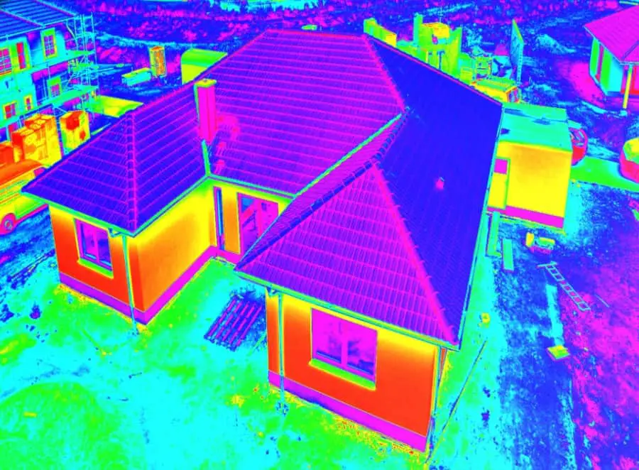
Perhaps not as heroic as stopping a fire or finding a lost child, inspections are a very profitable area for drone pilots. Roofing and Housing inspections with IR can find issues invisible to the naked eye. Things like holes in insulation, A/C unit leaks, and holes in the roofing are all things highlighted instantly when looking through a thermal lens.
Power Lines need regular inspections where hot spots can identify faulty wires or unnecessary resistance, it’s much easier for a drone to fly up to them than have a crew with a crane or ladder truck. Also, it is much safer to have a drone around high voltage lines that are having issues than a real person.
Farms and Factories can use drones to scan for leaks, since liquid is often colder than the surrounding environment. Potential farms can also use thermal images to look for groundwater and find the best areas to plant. They can see how the water drains and where it gathers.
Solar panel inspection is a big up and coming area. Drones with thermal cameras can identify a faulty solar cell by the heat signature it throws off. This can save a huge amount of time over someone going to check each panel.
Flying up to radio towers and under bridges to analyze their structure are all things that benefit from the high mobility of drones and the information that IR cameras can gather.
This is only a glimpse into all the different areas thermal imaging can be utilized to inspect. At the end I will add more articles going into the specifics for these individual areas.
What do you need for Drone Thermal Imaging?
If you want to get into the world of thermal imaging using drones, you are in luck. There are a lot of options to fit any need or budget, ranging from simple inspection drones that can fly inside of buildings to gigantic fixed-wing multispectral monsters that cost hundreds of thousands of dollars and can fly non-stop for days on end. All you really need to get into it, though, is a drone and a thermal camera. Check out this post on the 5 Affordable Thermal Drone Setups.
In conclusion, the applications and possibilities of being able to fly thermal cameras through the air using drones as a platform is endless. From saving lives to inspecting roofs with the same camera and drone it is truly an amazing technology.