
Despite being mostly known for aerial photography, the uses of drones are increasing by the clock. Multiple industries are integrating drones into their fieldwork, whether its photography, surveying, or even the anticipated parcel delivery.
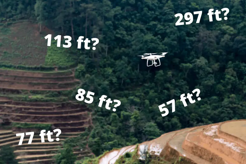
That’s why the importance of measuring and controlling the drone’s altitude is on the rise. Altitude, apart from the other 2 dimensions, is a bit ambiguous and hard to measure. Do they use regular GPS? Does the barometer have something to do with it? How do DJI drones measure it? Most DJI drones measure altitude using a barometric sensor with an AGL (Above Ground Level) reference.
That’s what we’ll be exploring today. Read on!
GPS – The Global Positioning System
We’ll be breaking down the whole thing to you, but first, let’s start with some basics.
Back in 1973, the US started pursuing a promising project, where it sent 24 satellites divided into 6 Earth-orbited planes, all orbiting at a 13,000-mile distance from the Earth. They developed algorithms to synchronize the time, location, and velocity data received from these satellites to pinpoint the location of any point on earth.
The result? The renowned Global Positioning System or the GPS that’s installed on all our devices right now.
While being perfect at determining the horizontal coordinates of a point, the GPS has a pretty bad reputation for measuring altitudes.
The matter is complex, but to put in simple terms, the GPS measures the elevation of a point from the earth’s center based on something’s called an “ellipsoid” model; a mathematical model that represents the earth as an elongated sphere with the North and South poles at the top and bottom points of it.
You can see where the problem is now. Don’t you? The earth’s surface isn’t regular; it has mountains, forests, craters, and oceans. In turn, this requires converting your ellipsoidal data into a practical elevation reference.
Barometer – Under Pressure!
I don’t know if your physics teacher has asked you to figure out a way to measure the height of a building using a barometer, but I’m sure that mine did!
A barometer is a simple device that measures atmospheric pressure—the weight of the air in the atmosphere. Initially, the classic barometer was a glass tube filled with mercury, the tube has a sealed end and another open one.
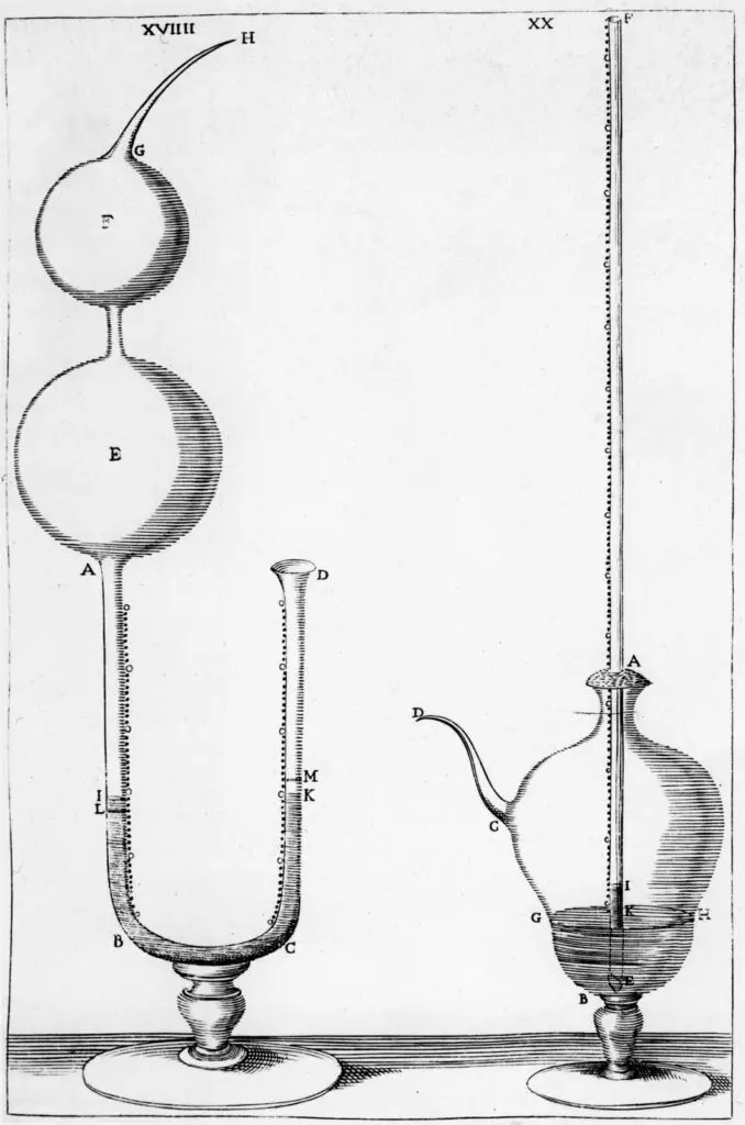
The tube is placed upside down in a reservoir, creating a vacuum seal at the closed side. The mercury falls down, then it tries to balance itself against the air pressure from the open end. When the mercury level finally stabilizes, the “reading” of its height in the tube is recorded. This reading represents the pressure value.
So basically, the whole thing relies on the principle that air pressure changes with the change of height above ground or sea level. If you’re a science guy who’s interested in the nuts and bolts of the process, you can check out this video below from TED.
You can imagine how impractical it is to place the classic barometer inside an artifact, not to mention a drone!
For this reason, the aneroid barometer was developed. A small device with an evacuated capsule, when pressure changes, the wall of the capsule deflects. This deflection is coupled with a needle that gives the reading. The whole thing is calibrated using old school mercury barometers, though.
What About DJI Drones?
Now back to our main question, how do DJI drones measure altitude?
The short answer, as I mentioned before, is that they use a barometric sensor to measure height with an AGL reference.
This translates into that: your Mavic will start with a zero measured height, no matter where you and it are positioned, and it’ll start measuring altitude from there. The direction will be indicated by a plus or a minus sign. Plus is going up, minus is down.
In some devices, the reading is converted into a graph that shows the drone’s height compared to its take-off point. Such a handy visualization feature!
DJI doesn’t convey this info on their official website, so we can’t say it’s official. Yet, we couldn’t find any evidence that they use GPS data to measure height, it’s just used for positioning. Whereas the barometric sensor is the one responsible for the altitude. This actually makes sense, considering the inaccuracy of the GPS in this situation.
The Accuracy Issue
Multiple users of DJI drones have reported their concerns about the accuracy of the barometric sensor. Honestly, it’s a valid concern.
Let’s start with the fact that the mere purpose of the drone’s barometric sensor is to maintain height, rather than actually “measure” it. This, in itself, makes the error margin tolerable.
Another thing to keep in mind is that any deviation in the barometer’s reading is supposed to happen because of abrupt or rapid changes in air pressure, an occurrence that’s highly unlikely to happen with a drone, given that its maximum flight time won’t exceed 35 minutes.
If you have to worry about something, however, it’d rather be the airflow of the drone’s propeller itself. Yet, this is subjective. It changes from one model to another and according to the weather conditions. Some abnormal airflows between high building and skyscrapers might have an effect as well, but again, it’s not the default case.
To solve such an issue, adding ultrasonic and visual sensors can be helpful, where they’ll record any abrupt changes that indicate an imprecision in the readings so that you can redo the process.
What About Limitations?
Every technology has its own drawbacks, and the height measurement function of drones is no different.
The results of a field-based experiment carried out at Arthur Temple College of Forestry and Agriculture revealed that although drones have proven to be efficient at measuring altitudes and they provided accurate measurements, they had to land and be turned off before each flight.
The goal is to reset the elevation algorithm so that they can get more accurate results, where their foundings reported that the drone’s accuracy had notably decreased when they used it multiple times without resetting the algorithm in between.
Apart from that, we have the well-known drone limitations; they’re noisy, they need to develop obstacle avoidance, and they have a maximum of 20 to 30 minutes of flight time.
The RTK System – The Latest Accuracy Fix
DJI has developed a high precision 3D positioning system, especially for its DJI A3 series flight. It promises an improved accuracy over the typical barometer and GPS!
The D-RTK integrates advanced algorithms into the positioning process. RTK stands for Real-Time Kinetic. In addition to GPS+BDS or GPS+ GLONASS dual-band, 4-frequency receiver. Resulting in enhanced accuracy that’s intended toward industrial and commercial uses.
The idea is to determine the absolute and relative positioning accuracies between the air system and the ground system. The absolute positioning is measured when the 2 systems are less than 10 km apart, where the ground system is the one responsible for accuracy. Then, the relative positioning accuracy is measured down to a centimeter-level.
The functionality of D-RTK triangulates both measurements to reach a final absolute accuracy of 2 cm.
To Wrap Up
When it comes to altitude measurements, especially in drones, the barometer gives more precise measurements. Compared to the GPS, even the barometer’s error margin is tolerable!
Now you know when you’re looking at your display exactly how and where that elevation number is coming from!